If your network records need to be accurate, we can help.
X3 captures, audits and maintains GIS records of utility assets throughout New Zealand — in the field and at the desk — backed by more than 35 years of utility industry experience.
AI is only as good as the data it's fed. As more utilities use AI to make planning and asset management decisions, gaps and errors in network records are amplified — no longer an inconvenience, they drive the outcome.
What we do
In-field GPS as-building
Gas · telecoms · electricity · waterCreating and updating GIS datasets by as-building newly installed and altered network infrastructure — accurately recording the location and attributes of every asset as it goes in the ground.
Delivered straight into your GIS, in your schema, via our in-house field software.Utility asset auditing
Gas · telecoms · electricity · waterInspecting overhead and underground assets for compliance with your existing datasets and standards, including Public Safety Management System (PSMS) audits for network operators.
Structured findings you can act on — not just a spreadsheet of defects.Office-based GIS record updating
Gas · telecoms · electricityOngoing maintenance and quality assurance of existing spatial datasets — enhancing the detail of assets already in the ground.
AutoCAD, shapefile and GIS-format delivery to suit your systems.Quality & safety documentation
Gas · electricityField capture standards, design manuals and public safety management systems written for New Zealand lines and gas companies.
Grounded in ISO 9000 and NZS 4801 systems experience.Custom field software
All networksIn-house applications, customised to each project, that speed up field capture and accurately record asset data — the same tools behind every X3 capture job.
Previously licensed to clients for their own capture programmes.Over 200 towns and cities. One team.
Since 2006, X3 has as-built newly installed fibre in more than 200 towns and cities throughout New Zealand — from Whangārei to Invercargill — for major network operators and their contractors. Every green pin is a town we've worked in.
As-built by X3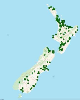
Experience
X3 was founded in 2006 by Shane Dolan, a GIS professional who had already successfully managed what was then New Zealand's largest field-based GIS data capture project in the utility sector. Across ten networks he managed the GPS recording of over 700,000 electricity assets, in projects of 7,000 to 250,000 assets each.
Since then X3 has as-built newly installed fibre in more than 200 towns and cities nationwide, audited electricity and gas networks across multiple regions, and written quality and safety documentation for the electricity sector.
Shane holds an MBA and a Graduate Diploma in Geographic Information Systems, is a registered Line Mechanic, and served over seven years on the Electrical Workers Registration Board — with ongoing governance, risk and leadership training through the Institute of Directors and Waikato University. Formal qualifications and trade experience mean we understand both the assets in the ground and how your business will use and maintain the data long after we've captured it — asset management, compliance and planning, not just dots on a map.
View Shane on LinkedIn